
In class yesterday we talked about eclipses and so here’s the post about it!
The totally awesome (and very dedicated) Mr. Eclipse (i.e., The Ultimate Resource for Eclipse Photography) is a favorite of NASA so they use his diagrams on their eclipse website.
The foremost resource for the 2017 eclipse is eclipse2017.org. The Interactive Google Map they have linked is AMAZING. The image below is from that map. The Wikipedia article is pretty good as well.
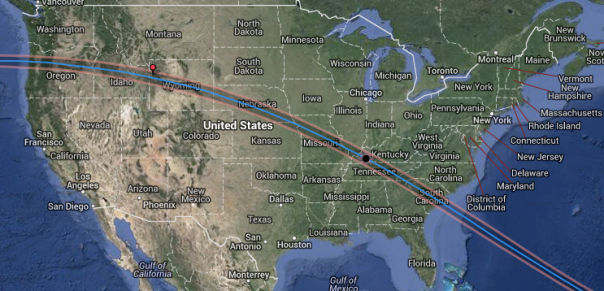
Path of the 2017 Total Solar Eclipse. Can’t see totality unless within that line.
On the map, you can zoom in and click on a location which will bring up information about time of partial eclipse start/end, totality start/end, duration of totality, and anything else you might need. The map also has information for areas in the partial eclipse regions.
You should make plans!!
Ooo, you can also see a great map here of total solar eclipses in the US in the next 50 years!! Make more plans!

![]()