VU BreakThru

Home » News » Vanderbilt IRIS Initiative: Shaping the Infrastructure of Tomorrow
Vanderbilt IRIS Initiative: Shaping the Infrastructure of Tomorrow
Posted by anderc8 on Thursday, January 18, 2018 in News, TIPs 2016.

Associate Professor of Civil and Environmental Engineering Caglar Oskay
Written by Associate Professor of Civil and Environmental Engineering Caglar Oskay & Post-Doctoral Research Scholar Alessandro Fascetti
A 2016 Trans-Institutional Program (TIPs) award, the Vanderbilt Initiative for Intelligent Resilient Infrastructure Systems (IRIS) continues to make progress. The development of the program coincides with the university becoming a recognized leader in the innovation of civil infrastructure.
The faculty collaborating on the project are defining strategies and scientific tools to measure the resilience of the country’s Flood Protection Infrastructure (FPI), predict its functionality as well as inform stakeholders – sharing information in the most efficient way based on the interlocutor.
IRIS’s vision builds upon the two pillars of the project: the physical modeling of the infrastructure (Data & Simulations) and the decision support system (Risk-Based Decision Making & Human Interface). The former aims to define the mathematical tools needed to assess the resilience of the FPI, while the latter provides a comprehensive system that transfers information to stakeholders in the most efficient way possible.
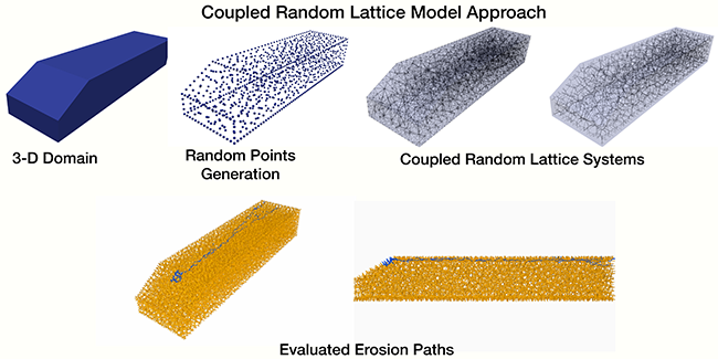
The effort on the physical modeling of earthen infrastructure (such as river levees and dams) led to the design of computational tools to predict the progression of internal erosion in the FPI, thereby allowing the team to evaluate the potential for erosion in a specific structure. With this information, it is possible to identify critical zones susceptible to localized damage that will be more likely to fail in the event of a natural hazard. The IRIS team is also designing tools to perform real-time monitoring of the infrastructure.
The support of the TIPs program allowed the team to purchase a developer-level Unmanned Aerial Vehicle (UAV) and a LiDAR sensor, which can scan more than 300,000 points per seconds on a 360˚ radius. The team is currently performing a series of test flights to validate the capabilities of the toolset that will be used in upcoming field campaigns.
We are actively increasing the outreach of the initiative by building fruitful collaborations with government partners (such as USACE, local and state-level organizations), as well as promoting different teaching and research activities involving undergraduate and graduate students.
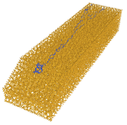
Erosion path evaluated by means of the proposed numerical model
The future of the country relies on the sustainability and resilience of our infrastructure. The importance of our research is testified by the National Academy of Engineering, which includes this topic among its Grand Challenges for Engineering in the 21st century. More than 50 percent of the American population lives in areas protected by levees, making FPI one of the most important and exciting problems to solve for our society. Vanderbilt is actively contributing to this effort by supporting the IRIS Initiative through the 2016 TIPs Award.
Leave a Reply
Recent Posts
 Perceptions of AIs, Humans, and Others (Part 2) » 5.28.19
- Perceptions of AIs, Humans, and Others (Part 1) » 5.23.19
- Esteemed Writer Ted Chiang visits Vanderbilt (Part 2) » 4.17.19
- Esteemed Writer Ted Chiang visits Vanderbilt (Part 1) » 4.15.19
- Sublating Binaries: Smart Vehicles as Defensive Drivers » 4.1.19
- Sublating Binaries and an Intelligent Vehicles Case Study » 3.28.19
 HPV Symposium Set For March 1 » 1.28.19