VU BreakThru
Home » Data Science Methods for Smart City Applications » Recapping the First Year of ‘Data Science Methods for Smart City Applications’
Recapping the First Year of ‘Data Science Methods for Smart City Applications’
Posted by anderc8 on Wednesday, May 23, 2018 in Data Science Methods for Smart City Applications, News.
This spring, the University Course Data Sciences Methods for Smart City Applications was offered to Vanderbilt University undergraduate and graduate students for the first time. The course was designed to examine and address issues facing cities and metropolitan areas by bringing together concepts and methodologies from systems engineering, data sciences and machine learning, modeling and simulation, optimization and social sciences. Students reviewed these topics and focused on machine learning, Python programming and script generation, qualitative methods for data collection, and ethics issues related to data collection and privacy.
A significant portion of the semester was devoted to team projects with students working together. The projects covered four separate themes: transportation, energy, gentrification and transportation, and emergency response. Each team worked with a faculty mentor and a graduate student advisor to research their projects, implement qualitative and quantitative methods for data collection, and analyze the data to answer research questions. The students presented their findings at the end of the semester and submitted reports.
Over the next week or two, we will share four student-written blogs describing the projects.
Vanderbilt Campus Mobility and Transportation
Written by Will Barbour, Jacob Berk, Derek Brody and Ben Schechter
The campus layout and location of Vanderbilt creates mobility challenges due to its urban setting and arboretum interior. Some of the university’s facilities are original to campus and have been retrofitted with accessibility features and new additions, making them difficult to navigate. For these reasons, Vanderbilt is interested in a transportation solution that helps users navigate to, from and within campus. Our project team has a range of expertise well-suited to the planning and execution of the project, including engineering, computer science, political science and organizational development. The solution our project team deployed leverages campus GIS data to create a network graph of campus on which standard routing algorithms can be applied. Users can define routing preferences to accommodate for accessibility needs or mode of transportation. Route guidance is given to the user in the form of standard textual directions, as well as turn-by-turn navigation to help with the tricky layouts of sidewalks.
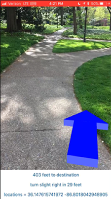 Routes are calculated on a Python backend server, which communicates with a user’s device over the internet to establish the origin, destination, routing preferences and user location. The device sends GPS location updates to the server, which responds with updates to the route guidance directions. The augmented reality guidance system overlays a directional arrow on the phone’s live camera feed and updates the arrow direction for turn-by-turn navigation. The mobile application has thus far been implemented in an iOS application as a proof of concept. The computational aspects of the project were challenging, but well defined, though some of the more difficult aspects of the project development were on the user side. Vanderbilt is interested in continuing development on the platform and adding the additional functionality that was envisioned for the long-term project goals including an enhanced user interface, real-time parking information, and integration with Nashville transit.
Leave a Reply
Recent Posts
 Perceptions of AIs, Humans, and Others (Part 2) » 5.28.19
- Perceptions of AIs, Humans, and Others (Part 1) » 5.23.19
- Esteemed Writer Ted Chiang visits Vanderbilt (Part 2) » 4.17.19
- Esteemed Writer Ted Chiang visits Vanderbilt (Part 1) » 4.15.19
- Sublating Binaries: Smart Vehicles as Defensive Drivers » 4.1.19
- Sublating Binaries and an Intelligent Vehicles Case Study » 3.28.19
 HPV Symposium Set For March 1 » 1.28.19