Design Results & Recommendations
Challenge 1: Efficient Interchanges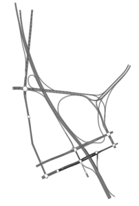
We addressed the flow of traffic and the safety concerns mentioned with the design shown to the right. We designed all curves in accordance with TDOT-recommended turn radii. Our design includes streamlined movement to and from Ellington Parkway and maintains access to and from the Central Business District. It enables new access to East Nashville via an exit onto Woodland Street from I-24, and it attempts to minimize merge lanes while simplifying the entanglement of Ellington Parkway with a Y-stack interchange. The next step in evaluating the design would be testing its effectiveness with models and simulations, but we didn’t have the time or the resources to do this effectively.
Challenge 2: Multimodal Infrastructure
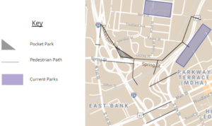 Preliminary research revealed the need for pedestrian connections across Spring Street and S 5th Street. This would ensure access to the additional space freed up by the new design. Our design for pedestrian paths on the right shows planned connections over the existing infrastructure. It suggests a park in place of the low-traffic portion of Dickerson Pike and connects that park to the existing McFerrin and Frederick Douglass Parks.
Our plan maintains the need for improved underpasses. Recommendations for each underpass include:
- Beautification and landscaping projects
- Burying utilities
- Improved lighting
- More space for pedestrian movement
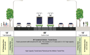
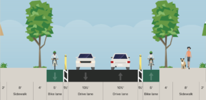
We adopted cross sections for Main Street and Woodland Street from Nashville’s Major and Collector Street Plan to provide a visual for the future of the space. These cross sections can be seen below. The nMotion High Capacity Transit Briefing Book details the challenges of constructing light rail on Main Street. It is important for future development to contribute to Main Street with right-of-way flexibility and pedestrian walking space. Similarly, Woodland Street can benefit from expanded right-of-way in order to better suit bicycles and pedestrians.
Challenge 3: Valuable Space
The redesigned road network of Spaghetti Junction opens up an estimated 15 acres of usable space. From examining existing data and plans to suggest best uses for the space, we found that a mixed use-development including greenspace, a neighborhood transit hub, housing, and grocery options could bring much value to those living nearby.
Many elected officials and community leaders have identified the need for affordable housing in Nashville. Another need is providing access to fresh, nutritious food, which has been a concern for parts of East Nashville. Transportation is a key factor linking food deserts to supermarkets, and the range of bus services moving from food deserts to Spaghetti Junction makes the space an intriguing option for a neighborhood transit hub. While there was not a proposed transit hub in the Spaghetti Junction area in the 2016 nMotion plan, building one would bring economic benefits to those in the Spaghetti Junction communities.
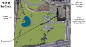
To the left is our proposed layout for the redeveloped Spaghetti Junction land. Worth noting is the space that is still available even after including a major development and a greenspace. Also of note is our idea of capping the lane connecting James Robertson Parkway to Ellington Parkway and allowing that cap to connect the new development to adjacent neighborhoods.
Site Navigation
Introduction
Significance
Design Goals
Preliminary Research
Design Results & Recommendations
Further Research