Preliminary Research
Pedestrian Travel
The quality of public space, which includes streets, helps determine urban prosperity. The UN-HABITAT’s global public space toolkit highlights several measures for evaluating the quality of an urban area, two of which show deficiencies present in Spaghetti Junction: Access and Comfort.
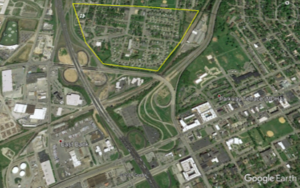
Inaccessibility and discomfort are evident in two pedestrian pathways in Spaghetti Junction. The first is outlined on the right. I-24, a CSX rail line, and a high-traffic road isolate the neighborhood adjacent to Spaghetti Junction. This makes movement to and from the neighborhood challenging at best. Additionally, important destinations, like grocery stores, remain far away or difficult to access, creating a positive feedback loop of cars, congestion, and heightened discomfort for pedestrians.
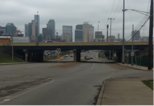 The other instance of poor access and discomfort exists for pedestrians who hope to cross I-24. There are three underpasses in Spaghetti Junction, and they generally appear like the underpass at Woodland Street shown to the left. Worth noting is the poor lighting and the small sidewalks, already fighting for space with utilities and street signs, next to multiple, wide road lanes. The layout of the underpass does not encourage a perception of comfort and safety for pedestrians. This makes promoting the space as walkable and thriving more difficult, and it restricts movement to East Nashville or East Bank.
Bicycle Travel
Prioritizing bicycle travel was key to the success of the Spaghetti Junction project, and it aligns with the need to improve the level of service concerns highlighted in the RTP. Most important to this effort is Woodland Street, which offers a connection to other paths while avoiding the high-volume James Robertson Parkway and several busy interchanges.
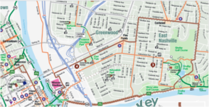
In this map produced by Walk Bike Nashville, the brown section from Five Points to I-24 in Figure 4 was our primary focus for bicycle travel, since it avoids the high-traffic James Robertson Parkway and remains accessible to businesses and neighborhoods. It currently only has a shared lane despite some recent groundwork to expand. The road faces constraining right-of-ways, yet development can expand these right-of-ways to better suit other modes of travel.
Automobile Travel
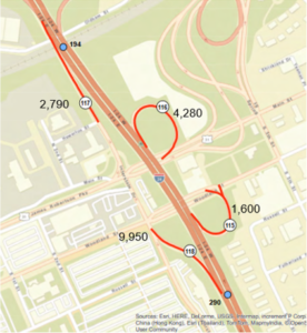
 The junction formed at the project area is vital to the flow of vehicles in and out of Downtown Nashville. To design a better road network, it was important for us to understand where people are traveling and the safety concerns associated with those paths. The pictures to the right show the AADT (Average Annual Daily Traffic, or the average number of vehicles per day on a given road) at key ramps in the junction. Although there are a variety of considerations, the data show that the highest traffic volumes are from commuters going to and from both Ellington Parkway and the Central Business District.
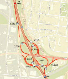
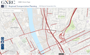
 Nashville crash data suggests that merge lanes and varying speeds consistently produce collisions at the cloverleaf section and the Ellington Parkway section. The sections are circled in the picture below. Because crashes occur in similar locations over separate years, it suggests that the design of the roadways and other factors may lead to accidents.
Public Transport
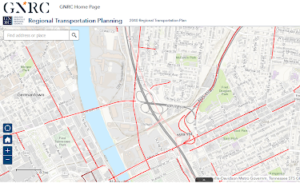
 Recent public transportation projects have established a framework of bus services connecting Spaghetti Junction to other areas along the corridor. Projections by GNRC, though, show that these still may not be enough. According to a 2018 study, some road links were congested in 2018 but most will be heavily congested by 2040, even with the planned bus rapid transit expansion along Ellington Parkway.
Site Navigation
Introduction
Significance
Preliminary Research
Design Goals
Design Results & Recommendations
Further Research