Why San Bernardino National Forest
-
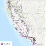
- Fire boundaries 1984 – 2017
-
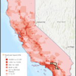
- Population Density of CA
One of the first things the team did was decide on where to deploy the device. This would help the team set parameters for what sensors need to be included in the device as well as what the minimum data transmission range needs to be. The search was quickly narrowed down to public lands such as National Parks or Forests. This decision was made due to a recent increase in visitation that was also aligned with a decrease in funding and park rangers. Fewer park rangers means important tasks such as trail maintenance are being put on hold in order to manage the crowds and there are less park rangers to watch for fires.
The next decision the team made was to look specifically at California for public lands that would benefit from our device. For the past several years, California has had the largest number of wildfires as well as the most acres burned every year. Looking at population and fire boundary history maps created by Katherine in GIS, the team came to decide that San Bernardino National Forest in Southern California would be an ideal candidate for our device.
San Bernardino National Forest is located just outside of Los Angeles in between Riverside and Palm Springs. Referencing Katherine’s GIS maps, the team noticed the numerous large wildfires that have occurred in this area. One fire in particular, the Old Fire in 2003, caused $1.2 billion in damage. The Old Fire was caused by arson and consumed 91,000 acres of San Bernardino County. Further, the San Bernardino National Forest also experiences the natural phenomenon of the Santa Ana winds, dry and warm winds that start inland of SOCAL and flow down on their way to the ocean, heating up as they descend and often occurring during the driest part of the year. These winds heighten the risk of human initiated fires growing to catastrophic proportions.